| Lectures on Physics has been derived from Benjamin Crowell's Light and Matter series of free introductory textbooks on physics. See the editorial for more information.... |
|
Home  Vibration and Waves Resonance Examples Collapse of the Nimitz Freeway Vibration and Waves Resonance Examples Collapse of the Nimitz Freeway |
|||||


|
  |
||||
|
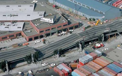
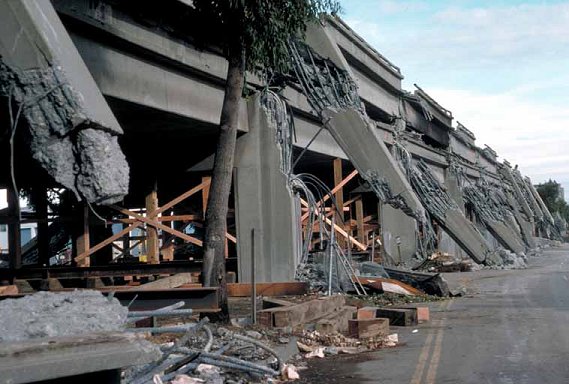
Collapse of the Nimitz Freeway in an earthquake
I led off the chapter with the dramatic collapse of the Tacoma Narrows Bridge, mainly because a it was well documented by a local physics professor, and an unknown person made a movie of the collapse. The collapse a section of the Nimitz Freeway in Oakland, CA, during a 1989 earthquake is however a simpler example to analyze. An earthquake consists of many low-frequency vibrations that occur simultaneously, which is why it sounds like a rumble of indeterminate pitch rather than a low hum. The frequencies that we can hear are not even the strongest ones; most of the energy is in the form of vibrations in the range of frequencies from about 1 Hz to 10 Hz. Now all the structures we build are resting on geological layers of dirt, mud, sand, or rock. When an earthquake wave comes along, the topmost layer acts like a system with a certain natural frequency of vibration, sort of like a cube of jello on a plate being shaken from side to side. The resonant frequency of the layer depends on how stiff it is and also on how deep it is. The ill-fated section of the Nimitz freeway was built on a layer of mud, and analysis by geologist Susan E. Hough of the U.S. Geological Survey shows that the mud layer's resonance was centered on about 2.5 Hz, and had a width covering a range from about 1 Hz to 4 Hz. When the earthquake wave came along with its mixture of frequencies, the mud responded strongly to those that were close to its own natural 2.5 Hz frequency. Unfortunately, an engineering analysis after the quake showed that the overpass itself had a resonant frequency of 2.5 Hz as well! The mud responded strongly to the earthquake waves with frequencies close to 2.5 Hz, and the bridge responded strongly to the 2.5 Hz vibrations of the mud, causing sections of it to collapse.
|
|||||
| Home Vibration and Waves Resonance Examples Collapse of the Nimitz Freeway |
|
||||