 This is the Web Edition of "A Trip Into Space", a Coimbra-based electronic book on space science. Both the texts and the photos are by courtesy of National Aeronautics and Space Administration.
| This is the Web Edition of "A Trip Into Space", a Coimbra-based electronic book on space science. Both the texts and the photos are by courtesy of National Aeronautics and Space Administration.
|
A Trip Into Space  Pluto Pluto - Map Of The Surface Pluto Pluto - Map Of The Surface |
|
| See also: Pluto Fact Sheet, Pluto - Surface View, Pluto And Charon |   |
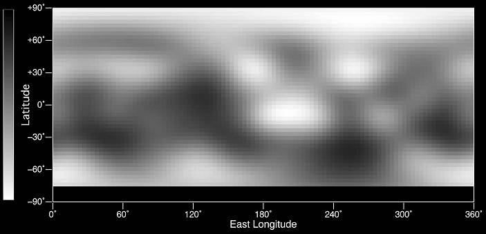
This is the first image-based surface map of the solar system's most remote planet, Pluto. This map was assembled by computer image processing software from four separate images of Pluto's disk taken with the European Space Agency's (ESA) Faint Object Camera (FOC) aboard NASA's Hubble Space Telescope. Hubble imaged nearly the entire surface, as Pluto rotated on its axis in late June and early July 1994.
The brightness variations in this map may be due to topographic features such as basins and fresh impact craters. However, most of the surface features unveiled by Hubble are likely produced by the complex distribution of frosts that migrate across Pluto's surface with its orbital and seasonal cycles. Names may later be proposed for some of the larger regions.
Image reconstruction techniques smooth out the coarse pixels in the four raw images to reveal major regions where the surface is either bright or dark. The black strip across the bottom corresponds to the region surrounding Pluto's south pole, which was pointed away from Earth when the observations were made, and could not be imaged.
Pluto itself probably shows even more contrast and perhaps sharper boundaries between light and dark areas than is shown here, but Hubble's resolution (just like early telescopic views of Mars) tends to blur edges and blend together small features sitting inside larger ones.
Credit: Alan Stern (Southwest Research Institute), Marc Buie (Lowell Observatory), NASA and ESA.
Last Update: 2005-Nov-29